Page Banner

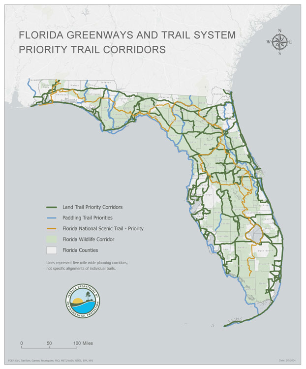
Florida Greenways and Trails System Plan and Maps

To view each regional map draft please click the links below:

Northwest Region                  West Central Region

North Central Region             West Central - Sarasota County

Northeast Region                   West Central - Pinellas County

East Central Region                Southern Region

2024-2028 Florida Greenways and Trails System Plan and Maps Update

People across Florida are using greenways and trails in record numbers, and as we continue looking forward, valuable input was gathered at public meetings in 2022 and 2023 regarding updates to the five-year Opportunity and Priority Maps for Florida's network of non-motorized land-based trails. In September of 2023, the public will be asked to provide input on the draft Florida Greenways and Trails System Plan, so stay tuned!

Public Meetings Held

DATE AND TIME: Sept. 22, 2022, 5 p.m. - 7 p.m.
PLACE: Titusville Welcome Center, 419 S Hopkins Ave., Titusville, FL 32780
 
DATE AND TIME: Sept. 26, 2022, 5 p.m. - 7 p.m. CT
PLACE: City Hall, 501 Harrison Ave., Panama City, FL 32401
 
DATE AND TIME: January 31, 2023, 5:00 p.m. – 7:00 p.m.
PLACE: Selby Public Library, 1331 1st St, Sarasota, FL 34236
 
DATE AND TIME: February 1, 2023, 5:00 p.m. – 7:00 p.m.
PLACE: Winter Garden City Hall – Council Chambers, 300 W Plant St, Winter Garden, FL 34878
 
DATE AND TIME: February 2, 2023, 5:00 p.m. – 7:00 p.m.
PLACE: DeBary Hall - Stable House, 198 Sunrise Blvd, DeBary, FL 32713
 
DATE AND TIME: February 8, 2023, 5:00 p.m. – 7:00 p.m.
PLACE: Dunedin Public Library, 223 Douglas Ave, Dunedin, FL 34698
 
DATE AND TIME: February 16, 2023, 5:00 p.m. – 7:00 p.m.
PLACE: Ed Ball Building – First Floor Training Room, 214 N Hogan St, Jacksonville, FL 32202
 

Timeline at a Glance

  • The Florida Greenways and Trails System (FGTS) plan identifies existing trails, as well as planned and conceptual trail corridors. The plan also identifies the goals, objectives and actions needed to connect this system statewide.
  • This plan supports and builds upon local and regional trail efforts to identify one overall trail network that is the focused vision of a connected statewide system.
  • This will be the third update to the Florida Greenways and Trails System Plan since Connecting Florida’s Communities laid the groundwork in 1998 to implement the many greenways and trails programs and projects that exist today.
  • The current FGTS Plan guides the implementation of the connected statewide trail system through 2023.
  • The intent of this plan is to help provide guidance and to encourage our partners and stakeholders to work together effectively to reach mutual goals.
 

2024-2028 FGTS Plan and Maps Update Schedule

2023

February 16 - Public meetings completed for draft 5-year Opportunity and Priority maps. Public comment period ended.
April 14 - Final Opportunity and Priority maps to be approved by the Florida Greenways and Trails Council
Sept. 1 - Begin soliciting public input regarding the draft 2024-28 Florida Greenways and Trails System Plan.
November 1 - Close of public comments on draft 2024-28 Florida Greenways and Trails System Plan.
December - Florida Greenways and Trails Council meeting – exact date and location TBD - Final DRAFT of the 2024-2028 Florida Greenways and Trails System Plan presented for approval.

2022

May 31 - Comment period closed for partners and stakeholders regarding 5-year Priority and Opportunity maps.
June 1 - Aug. 30 - Staff prepares DRAFT of proposed edits to the 5-year Priority and Opportunity maps.
Sept./Oct. - Public meetings throughout state to gather comments on proposed 5-year Priority and Opportunity maps (some meetings rescheduled to 2023 due to Hurricane Ian).

2021

July 1 - Begin updates to the Florida Greenways and Trails System Plan and Opportunity/Priority Trail maps.
Oct. 1 - Mapping tool will go live for partners and stakeholders to discuss proposed edits to the Priority and Opportunity maps.
Oct. 21-22 - Florida Greenways and Trails Council meeting - Discuss Goals and objectives and mapping tool.

GIS Data Download


Other Documents


Share:      
Last Modified:
April 7, 2023 - 11:16am

Some content on this site is saved in an alternative format. The following icons link to free Reader/Viewer software:
PDF: | Word: | Excel: