
Educational Resources
The Florida Geological Survey (FGS) provides publications and outreach to educators and students. The collection of resources below includes FGS articles, websites, videos, maps and interactive tools as well as high-quality external resources specific to Florida geology or geologic processes.
- Florida’s Geologic History: The Story Behind our Surface Features
- Karst Topography
- Aquifers and Florida’s Groundwater Resources
- Florida Fossils
- Rocks and Minerals of Florida
- Plate Tectonics
- Geologic Time
- Mapping Florida
- Careers in Geological Sciences

Florida’s Geologic History: The Story Behind our Surface Features
Have you ever wondered where the sand on the beaches in Florida originates? What is the reason shark teeth occur in rocks far from coastlines? Florida’s geologic history provides answers. Our history is one of changing sea levels, and the shape and size of the land mass that we recognize as Florida has been very different in the past.
Background
A Brief Geologic History of Florida: This FGS News and Research article, appropriate for advanced middle grades and higher, describes the geologic history of Florida and includes resources for readers who want to learn more.
Florida's Geologic History and Formations: This website describes the geologic history of Florida and provides images and links with information about formations that occur in Florida.
Lesson Ideas
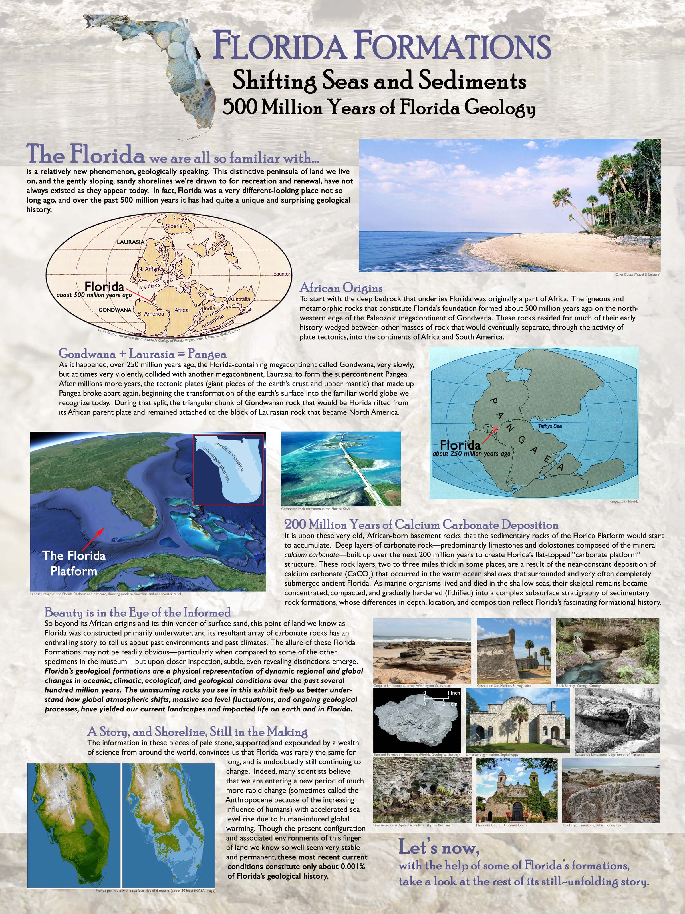
Florida Formations: Shifting Seas and Sediments: In collaboration with FGS staff, the Gillespie Museum at Stetson University developed this permanent exhibit exploring the geologic history of Florida. Associated resources include the Condensed Overview, Florida Formations Full Exhibit Text, Summary Questions for educators to use with the full text, a colorful Introduction to Florida Geology PDF and more. View the entire exhibit virtually on this website.
Videos

Rocks, Water, Life: Florida’s Geology: In this Florida Crossroads video, hear our former and current State Geologists describe Florida’s geologic history. See Florida’s basement rocks, housed at our Florida Geologic Sample Collections Facility. The video also highlights important outcrops as our former Assistant State Geologist visits notable geologic features around the state.
Posters
Geologic History of Florida: Display this colorful poster in your teaching space. Use it to learn fossils and formations of Florida and geologic events affecting the land that would become Florida.
Earth Systems: The Foundation of Florida’s Ecosystems: To learn more about surface features formed in Florida due to geologic processes, dive into this poster relating the underlying geology to the topography and ecosystems currently present in Florida.
Supporting Resources
Florida’s Geologic History StoryMap: Explore Florida’s geologic history using this online StoryMap.
Florida State Geological Sites and State Invertebrate Paleontological Sites StoryMap: Florida Statutes states that 'state geological sites' or 'state invertebrate paleontological sites,' as designated by the State Geologist, are locations of great and continuing significance to the scientific study and public understanding of the geological history of the state. There are currently nine state geological sites and one state invertebrate paleontological site. Explore them all through this online StoryMap.
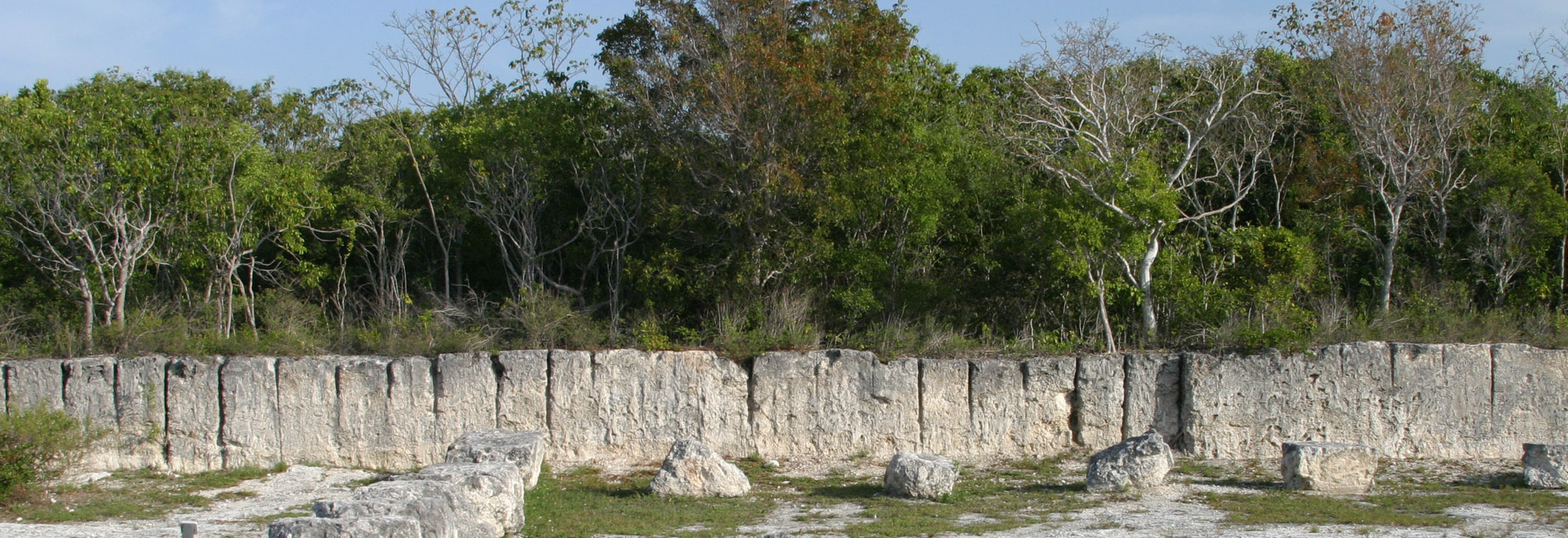
Karst Topography

Why does Florida have so many beautiful, large springs? How do sinkholes form? What is a swallet and where does the water go once it enters? Thousands of feet of geologically young limestone underlie Florida. Over time, limestone dissolves in naturally acidic water to form cavities that can develop into sinkholes, springs, swallets, karst lakes and cave systems. Explore geologic processes of Florida and the karst features that form as a result.
Background
Florida Springs: Florida has over 1000 springs! Read this website to learn what a spring is, how we classify them and where they are located. Learn about Florida legislation protecting springs, see highlighted FGS Springs Publications and find links to Water Management Districts in Florida.
A Guide to Identifying Springs and Seeps in Florida: In addition to over 1000 documented springs, Florida has innumerable seeps. This short FGS article reviews common characteristics of seeps and springs in Florida.
Florida's Geohazards: Explore more about geohazards in Florida on this website.
Geology in... the Real Florida: The Geology of Edward Ball Wakulla Springs State Park: Read about Edward Ball Wakulla Springs State Park, located in northern Florida, which features Wakulla Spring, one of the largest artesian springs in the United States and perhaps in the world. The park is located in the Woodville Karst Plain Province of the Ocala Karst District, and contains numerous springs, sinkholes and other karst features. The spring is connected to a vast network of conduits that extend both to the north and south of the spring and are part of the longest mapped underwater cave system in the United States.
Videos
Characteristics of Karst Geology: Watch this CPALMS Perspective Video for Educators to learn from State Geologist Harley Means about karst geology.

Hiking the Aucilla Sinks: Geology of the Floridan Aquifer Uncovered: In this video from 2021, then-Assistant State Geologist Harley Means brought Rob Diaz de Villegas, science writer of WFSU’s Ecology Blog, for a hike along the Aucilla Sinks Trail. This portion of the Florida Trail, located in the Middle Aucilla Wildlife Management Area, allows many opportunities to observe karst features and surface water-groundwater interactions between the Aucilla River and the upper Floridan aquifer.
Florida’s Caves and Karst Geology: Images, definitions and descriptions of caves, cave formations, karst geology and the development of karst features in Florida fill this colorful, silent online video created by the Gillespie Museum at Stetson University. The video has an associated downloadable student worksheet.
Posters
Florida’s Sinkholes: Explore what sinkholes are, how sinkholes in Florida form and where they are commonly located with this poster.
Florida’s First Magnitude Springsheds: This colorful poster explains springsheds and shows the springsheds of first magnitude springs in Florida.
Karst Educational Posters: This series of posters is highly detailed, containing information and images explaining karst processes, aquifers, groundwater/surface water interactions and bedrock features like porosity and permeability.
Springs of Marion County, Florida: Dive into the springs of Marion County, Florida, with this beautiful poster.
Supporting Resources

Florida Karst Resources: Links to FGS publications and report deliverables related to karst features are available on this website.
Sinkhole Type, Development and Distribution: Explore this map to learn detailed information about sinkhole formation in Florida.
Sinkhole FAQ: “Why do sinkholes form?” “I think I have a sinkhole in my yard. What should I do?” This website answers general sinkhole questions and delves deeper into issues for Florida residents and landowners.
Hurricane Season and Associated Uptick in Reported Sinkholes: Although sinkholes are not often thought of as an obvious result of weather-related events, they clearly can be. By changing the amount of water at the ground surface or in the underlying aquifer, sinkholes can be triggered. This relationship is evident in Florida, with its history of tropical storms, hurricanes and karst geology. Read this FGS News and Research article to learn more.
Florida Geomorphology Atlas Reveals How Geologic Processes Shape Florida's Landscape: Read and use the interactive Florida Geomorphology Atlas to explore how Florida’s geology determines Florida’s surface features.
Aquifers and Florida’s Groundwater Resources

Where does the water come from when you turn on your faucet? Florida has one of the most productive aquifer systems in the world. Sand and gravel aquifers near the surface provide water in some areas. In other areas, thick layers of limestone hold vast reserves of water, recharged by rainfall on the surface. Sinkholes, springs and swallets can directly connect surface water and groundwater, potentially allowing pollutants present on the earth’s surface to reach the aquifer and contaminate our drinking water supplies. Monitoring water quality and studying pathways that water can take underground helps us understand and protect our aquifer systems.
Background
Aquifer Essentials: An aquifer is a subsurface package of rocks and sediment that yields water in sufficient quantities to be economically useful to society. Learn more about aquifers through this website.

Videos
Water’s Journey: The Hidden Rivers of Florida: Check your school’s library for this gem! In this exciting PBS documentary, divers navigate the underwater caves of the Floridan aquifer and learn about the surface water/groundwater connections in a karst system.
Florida's Aquifer Adventure: Florida's aquifer systems, springs, caves and environmental issues are described in this 20-minute film.
Posters
Florida's Hydrogeologic Environment: Display Florida’s surface water/groundwater connection in this FGS poster.

Aquifers: This poster, within the Karst Educational Posters series, provides detailed information about aquifers, including definitions and a labeled diagram.
The Water Cycle: Produced by the U.S. Geological Survey, this detailed poster shows water’s path as it travels through pools and fluxes. Students can also explore this poster online through a zoomable visualization.
Supporting Resources
Aquifer Studies: Research at the FGS helps to characterize aquifers in Florida. This website explains some of that research and provides links to the upper Floridan aquifer potentiometric surface maps.
Tracing the Path of Water: Tracing refers to a collection of methods that allows scientists to trace where water goes. Through a series of three FGS News and Research articles, learn about dye tracing, non-dye tracing and why Florida needs a tracer database.
Florida Fossils

From marine fossils like clam shells, shark teeth and dugong ribs to terrestrial elephant and horse teeth, Florida is a fossil finders paradise. But what are fossils? How do we study them and what can we learn?
Background
What is a Fossil? What is a fossil? What is an artifact? This website explains the distinction.
FGS Fossil Collection: Did you know that "Herman," a mastodon skeleton displayed in the Museum of Florida History in Tallahassee, was recovered by FGS staff in 1930 from the depths of Wakulla Springs? Former State Geologist Herman Gunter wrote about the collection of “Herman” in articles published in Florida Woods and Waters and Florida Highways.
Lesson Ideas
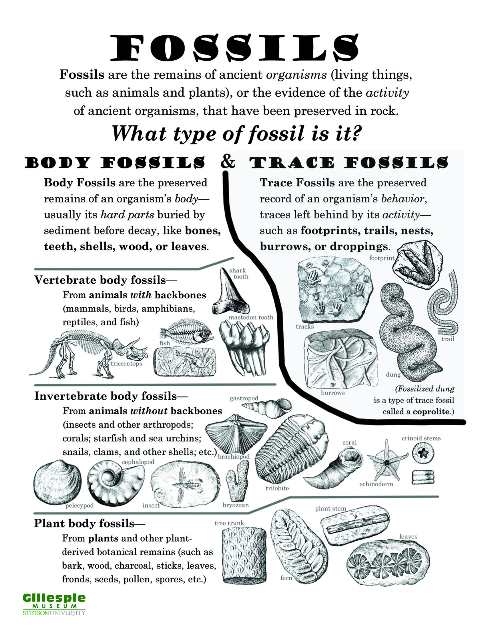
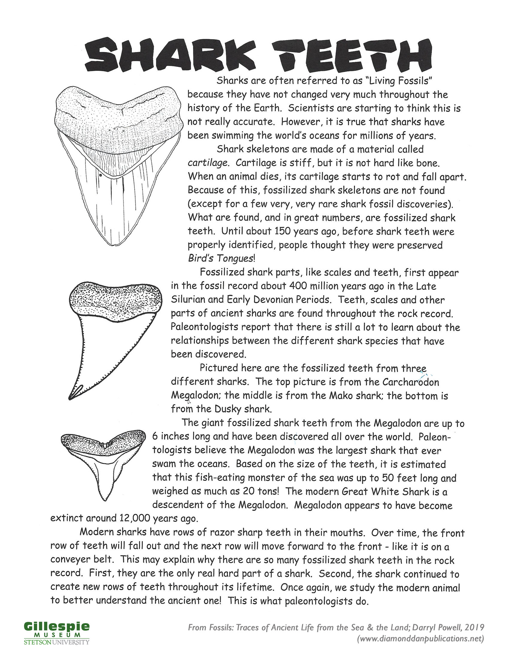
Fossil Types Coloring and Fact Sheet: Developed by the Gillespie Museum at Stetson University, this downloadable coloring sheet contains information about body and trace fossils. Explore the museum website to find more geoscience coloring sheets, including the Shark Teeth Coloring and Fact Sheet.
Deep Time Virtual Exhibit: Visit the Smithsonian National Museum of Natural History’s Deep Time Exhibit. See 3D versions of a mammoth and find teaching resources about paleontology and extinction.
Florida Fossils Matching Game: This printable activity from the Gillespie Museum at Stetson University allows students to see pictures of Florida fossils and the animals they once were.
Evolve or Perish Board Game: Created by Hannah Bonner at the Smithsonian Institution, this printable game is designed for 2-4 players and takes 15-30 minutes to play. It can be adapted for beginner or advanced levels and explores the history of life on Earth.
Videos

Why Megalodon (Definitely) Went Extinct: Explore the size, diet and evolutionary history of megalodon in this PBS video.
Forgotten Elephants of Deep Time: Now-extinct elephants, like mastodons and mammoths, once roamed Florida. In this Smithsonian National Museum of Natural History video, see elephant fossils and learn how scientists study teeth to gain insight into characteristics like diet and size.
Posters
Florida's Fossil Mammals: Display this poster of Florida’s Fossil Mammals in your classroom.
Selected Cenozoic Benthic Foraminifera from Florida: View scanning electron microscope images of fossil foraminifera, single-celled eukaryotic organisms, occurring in Florida’s geologic formations in this poster.
Common Cenozoic Echinoids from Florida: Compiled in conjunction with the Florida Museum of Natural History, this FGS poster displays fossil echinoids, like sand dollars and sea biscuits, found in Florida.
Supporting Resources

Walter Schmidt Museum of Florida Geology StoryMap: Explore Florida fossils on display at the FGS in the Walter Schmidt Museum of Florida Geology online StoryMap.
3D Fossils from the Florida Geological Survey Collection: This publicly available digital collection provides access for detailed 3D examination of Florida fossils. These models can be downloaded and used with 3D printing software to print physical copies of Florida fossils anywhere.
Florida Fossil Collecting: Learn where and what you may collect in Florida.
Megalodon: Extinct Apex Predator of the Ocean: Between 23 and 3.6 million years ago, a super predator swam the oceans. Otodus megalodon, meaning “big tooth,” is more commonly known as the megalodon shark. Read about megalodon and see fossils on display at the FGS.
Invertebrate Paleontology Collection at the Florida Museum of Natural History: Explore collections at the Florida Museum of Natural History online, including their virtual tour of collections and Rare, Beautiful & Fascinating Online Exhibit.
Vertebrate Paleontology Collection at the Florida Museum of Natural History: Learn about Florida's extensive vertebrate paleontology record, examine vertebrate fossil species of Florida and explore vertebrate fossil sites of Florida.
Rocks and Minerals of Florida
What geologic materials are found in Florida? Where do we find them? How do people use them as resources today? Limestone, quartz sand, clay, phosphate and heavy mineral sands are all mined in Florida today. We use them to construct buildings and roads, fertilize our crops, create technology and even brush our teeth!
Background

All About Rocks: What is a rock? What are the three rock types? Learn about the rock cycle on this website.
Florida Rocks and Minerals: See images and learn about the rocks and minerals found in Florida on this website.
What Types of Rocks are Mined in Florida? Limestone, clay, peat, phosphate rock, sand and gravel, crushed stone and heavy mineral sands are all mined in Florida. This short article provides information about what is mined in Florida and how it is used.
Audio/Video
History of Florida's Geological Resources: Florida's state mineral is chert, which was used by Native Americans to develop spears and other tools throughout the state. Listen to this radio program interview of State Geologist Harley Means as he describes the history of Florida's geologic resources.
The Earth Rocks All Around You! Former FGS Director and State Geologist of Florida describes geologic materials of Florida in this webinar.
Posters
Florida Minerals Poster: Display these beautiful Florida minerals in this FGS poster.
Florida’s Industrial Minerals: Making Modern Life Possible: Minerals from the earth are the building blocks of our modern society. Florida ranks among the top ten states in the nation in industrial mineral production. This poster explores mineral resources and mining in Florida.

Supporting Resources
Walter Schmidt Museum of Florida Geology: The long FGS tradition of providing publicly accessible geologic exhibits continues, and the legacy of our fifth State Geologist, Walter Schmidt, is commemorated by having the museum named in his honor. Contact Mabry Gaboardi Calhoun to schedule a virtual or face-to face tour of the museum.
GEOFACT: Origin, Mining and Uses of the Panhandle Sands: According to the Florida Department of Environmental Protection’s (DEP) mines database, there are 15 active sand mining operations in the Florida Panhandle, most of which consist of numerous open pits and borrow areas. The primary uses for the quartz sand, gravel and clay being mined in the Panhandle are for roadway construction, aggregate supply and commercial fill. Learn more in this article.
Plate Tectonics

Earth’s continents today look nothing like they did hundreds of millions of years ago. In fact, the continents move around through a process called plate tectonics. This process, recognized less than a century ago, is foundational to our understanding of geology.
Background
Earth Dynamics: Earth is more than 4.5 billion years old! During this unimaginable expanse of time, our planet has undergone drastic changes.
Florida’s African Connection: Would it surprise you to learn that some of the deep basement rocks underlying Florida were once part of Africa? Read this FGS News and Research article to learn more.
Lesson Ideas
Discovering Plate Boundaries: “A Data Rich Exercise for Discovering Plate Boundary Processes,” published in the Journal of Geoscience Education, is a whole-class activity appropriate for students in grades 6 and up, including adults. Students explore tectonic processes by analyzing data displayed in maps, interpret and share their findings and finally synthesize whole-class results into a model. This activity has been used and adapted by many geoscience education programs. The Teach the Earth portal provided by the Science Education Resource Center at Carleton College includes downloadable maps and modifications other educators have created to support teaching.
Video
Florida’s Tectonic History: This short video from the University of Chicago shows the location of Florida’s basement rocks throughout geologic history as they moved with tectonics plates. Florida’s current position is shown in yellow for reference.
Supporting Resources
USGS - This Dynamic Earth: Explore the ideas and research that led to our current understanding of the Theory of Plate Tectonics.
To learn more about how tectonics have shaped Florida, see Florida’s Geologic History StoryMap.
Geologic Time

Dinosaur fossils will never be found in rocks exposed on the surface in Florida. Why? The oldest exposed rocks on the surface in Florida belong to the Avon Park Formation, deposited during the Eocene Epoch, between about 56 and 34 million years ago. Dinosaurs went extinct at the end of the Cretaceous Period, around 66 million years ago. How do we learn about the timing of when rock layers and fossils were deposited? We use relative and absolute age dating techniques. Learn more with the resources below.
Lesson Ideas
It's a Date: Smithsonian’s National Museum of Natural History activity and facilitation guide is designed for interactively demonstrating the principles that geologists use to estimate the ages of rocks. This guide contains information about index fossils, absolute and relative dating as well as PDFs to print. Formal and informal educators can print and use this activity with little additional preparation needed.
Which Came First? Relative Time Puzzles: This lesson plan from the Indiana Geological and Water Survey includes content, vocabulary and an activity for middle and higher grades to explore how geoscientists assign relative ages to geologic strata.
Supporting Resources
The Geological Society of America Geologic Time Scale v. 6.0: The geologic time scale can be viewed and printed from this website.
Mapping Florida

Maps are an essential tool used by earth scientists to spatially display large amounts of data. They allow us to record our research findings, explore and interpret our world by linking information to locations. The FGS actively maps the geology, geomorphology and geologic resources of Florida. Learn how we do it and how you can explore with us!
Geologic Mapping in Florida: The Florida Geological Survey Mapping Initiative integrates research from various FGS mapping projects to achieve the FGS’s long-term goal of updating the statewide surficial geologic map of Florida. Discover the investigations that support the creation of a new statewide geologic map through this website, which includes contacts for individual projects.
Geologic Map of the State of Florida: Explore the most recently published FGS geologic map of the state of Florida.
Careers in Geological Sciences

Learn about the Florida Geological Survey: Watch the FGS in action in this 5-minute video that introduces our mission, partnerships, research and services.
How to Become a Florida Licensed Professional Geologist: Find information and links on this website to learn more about becoming a Licensed Professional Geologist in Florida.
Florida Geologic Sample Collections Facility: The Florida Geologic Sample Collections Facility contains more than 20,000 sets of samples from exploration, water and oil wells. Our facility holdings represent 2,474 miles of drilled wells and have an estimated value of approximately $1.7 billion. Learn more on this website.
Internship Program: Learn how to apply for the FGS Internship program, designed for college and university students who are interested in gaining real-world experience in the geosciences.
Contact Mabry Gaboardi Calhoun to ask a question, make a request or schedule a virtual or face-to face tour of the Walter Schmidt Museum of Florida Geology.
Mabry Gaboardi Calhoun
Mabry.GaboardiCalhoun@FloridaDEP.gov
850-617-0342