
State Geological Sites and State Invertebrate Paleontological Sites

Chapter 377.075(4)(e), Florida Statutes states that 'state geological sites' or 'state invertebrate paleontological sites,' as designated by the state geologist, are locations of great and continuing significance to the scientific study and public understanding of the geological history of the state.
The Florida Geological Survey is working with the Department of Environmental Protection's Division of State Lands, Florida State Parks and the state's water management districts to designate and preserve these important sites. As part of these efforts, it is the Florida Geological Survey's mission to provide the information and understanding of the geological significance of each site and educate the public through education and outreach efforts.
Learn more:
Criteria for state geological site designation.
Criteria for state invertebrate paleontological site designation.
There are currently nine state geological sites and one state invertebrate paleontological site. Learn more about each site by visiting the geological site's webpage or exploring the publications and articles in which each site is referenced.
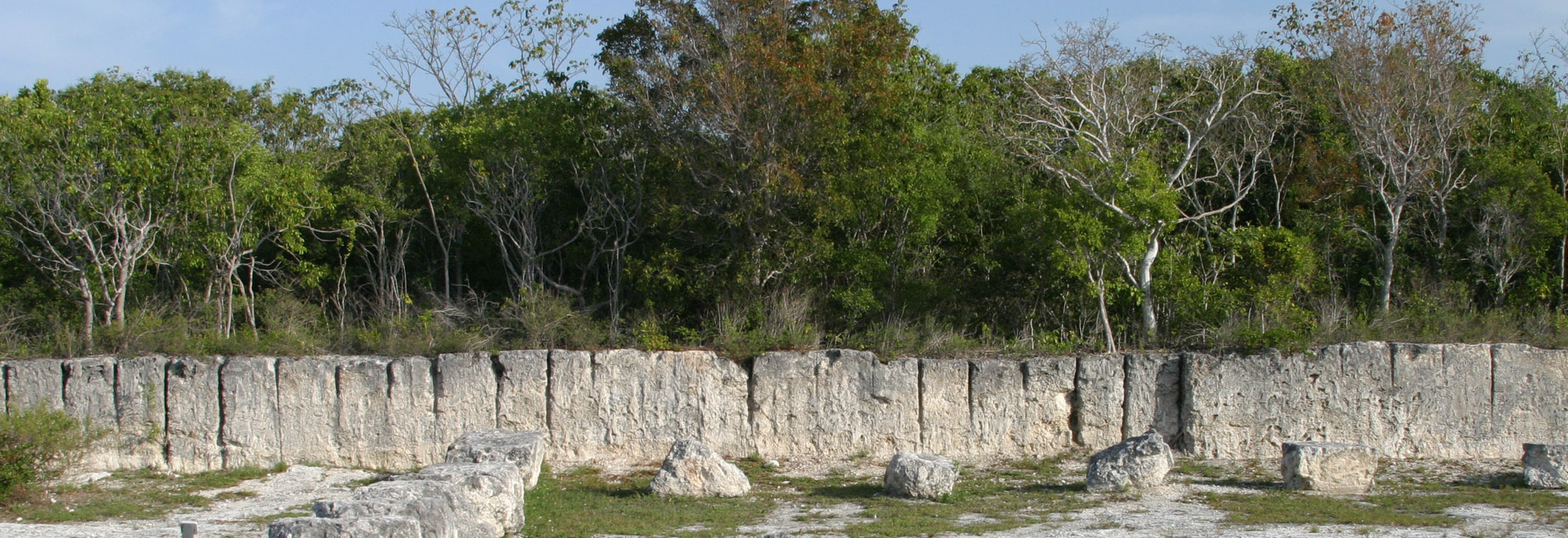
Windley Key Fossil Reef Geological State Park
Designated in 1998

The Windley Key Fossil Reef Geological State Park provides a beautiful exposure of a geological unit known as the Key Largo Limestone. Fossil corals and other ancient marine life are preserved in these rocks and record a unique part of Florida’s geologic history. Visitors to the park can stand inside a fossil reef - the same rocks that comprise the aquifer of the upper Florida Keys.
- Geology of Windley Key Fossil Reef Geological State Park
- Windley Key Fossil Reef Geological State Park
Publications/Articles:
Devil's Millhopper Geological State Park
Designated in 1998

Devil's Millhopper is a large, deep cover-collapse sinkhole. Sinkholes form when limestone is slowly dissolved by acidic groundwater over geologic time. This process, called dissolution, can create large cavities in limestone.
A sinkhole forms when the roof of a cavity in the limestone collapses and creates a depression at the land surface. Sinkholes and other landforms that develop in areas where limestone is near the surface are called karst features. Although sinkholes are common in Florida, Devil’s Millhopper is unique because it is one of the few places in Florida where more than 100 feet of geologic strata (rock layers) are exposed. The park is also unique because it is an important and beautiful example of how ecosystems (flora and fauna) develop in response to geological features.
Publications/Articles:
- Report of Investigations 85 - The Geology of the Western Part of Alachua County, Florida
- GSA Field Guide - Devil's Mill Hopper, Alachua County, Florida
Florida Caverns State Park
Designated in 2000

Florida Caverns State Park provides the opportunity to explore some of Florida’s amazing geological features. The park is located along the Chipola River in Jackson County where limestone formations that are more than 30 million years old are exposed. It is the only state park in Florida where visitors can take a guided tour through a large cave system and see some spectacular examples of cave formations including stalactites, stalagmites, columns and flowstone. These formations, called speleothems, formed over many thousands of years by the same process that created the cave passages for which Florida Caverns State Park is famous.
Publications/Articles:
- Leaflet 10 - Florida Caverns State Park, a Nature-Made Geologic Wonderland
- Open File Report 23 - Florida Caverns State Park, Jackson County, Florida
Edward Ball Wakulla Springs State Park
Designated in 2018

Wakulla Spring is located in a region known as the Woodville Karst Plain because the area contains numerous springs, sinkholes and submerged cave systems formed by the dissolving of limestone over thousands to millions of years. The extensive cave system beneath Wakulla Spring extends more than 44 miles and serves as a network of conduits that supply the more than 250 million gallons of water per day that discharges from the spring. Flow from the spring could fill an Olympic swimming pool every few minutes!
Early scientific work conducted at Wakulla Spring led to the discovery and excavation of mastodon remains by the FGS in the 1930’s. Numerous skeletal remains from extinct Pleistocene megafaunal animals have since been discovered along with archaeological evidence of the first people that inhabited Florida. Today, ongoing research using cutting-edge SCUBA technology and autonomous underwater vehicles is revealing more information about this world-class artesian spring.
Wakulla Spring is an Outstanding Florida Spring, a designation made by the Florida Legislature to limit groundwater withdrawals deemed harmful to springs. With its recent recognition by the International Union of Geological Sciences (IUGS) as a Geological Heritage Site, Wakulla Spring is now also an internationally recognized site of scientific and cultural importance.
Publications/Articles:
- Open File Report 22 - The Geology of Wakulla Springs
- Open File Report 47 - Lithology and Palynology of Cave Floor Sediment Cores from Wakulla Spring, Wakulla County, Florida
Falling Waters State Park
Designated in 2019

Falling Waters State Park is the only place in Florida where visitors can see a 70-foot-tall waterfall! When there is sufficient rainfall in the area, surface water flows down a small stream channel and over the rim of a large, circular depression and cascades some 70 feet before disappearing into a cave. This circular depression is the result of geologic processes that have shaped the landscape in this area and in many other parts of Florida. This geologic process, called dissolution, creates a landscape geologists refer to as karst topography. Karst topography includes features like sinkholes, springs, natural bridges and here in Falling Waters State Park, the waterfall.
Torreya State Park
Designated in 2022
Rock Bluff is a steep, tall limestone bluff within Torreya State Park that has been exposed by erosional activity of the Apalachicola River. As this large river moves across the landscape, it erodes the underlying rocks creating the broad valley it occupies, which is called a floodplain.

Rock Bluff is located at the eastern edge of the Apalachicola River floodplain and is one of the tallest natural geologic exposures of rock and sediment in Florida. When strata are exposed at land surface, the area is known to geologists as an outcrop. At 100 feet tall, the outcrop at Rock Bluff is among the best in Florida!
Jennings Bluff Tract
Designated in 2023
The Jennings Bluff Tract is owned and managed by the Suwannee River Water Management District, ensuring that this tract's land and water resources are protected and conserved.

Jennings Bluff Tract is a premier example of how surface and groundwater systems are interconnected. Water flowing into the Dead River swallet enters the Upper Floridan aquifer and travels south for approximately 10 miles, where it then discharges into the Suwannee River through both Holton Creek Rise and the Alapaha River Rise in just a matter of days.
Numerous karst features exist on this parcel. Silicified oyster beds and other fossils can be found in the limestone walls exposed along Dead River and the Alapaha River. Numerous outcrops occur in the sinks along these rivers.
Archeological items like stone tools from prehistoric Native Americans have been found on this tract. The tract is adjacent to a historic cemetery, signifying the area's significance in human history.
***It is important to note that collecting fossils or artifacts from District-owned land is prohibited. ***
- Jennings Bluff Tract - FGS News & Research article
- Jennings Bluff Tract - Suwannee River Water Management District
Publications/Articles:
- Alapaha Swallets Dye Trace Project
- Guidebook NO. 63 - Karst Hydrogeology of the Upper Suwannee River Basin, Alapaha River Area - Southeastern Geological Society
- Open File Report 27 - The Geology of Hamilton County, Florida
- Report of Investigation 87 - The Geology and Water Resources of the Upper Suwannee River Basin, Florida
Paynes Prairie Preserve State Park
Designated in 2024

Within its 23,000-acres Paynes Prairie Preserve State Park contains some of the best examples of karst features in the state, including an upland expanse with abundant sinkholes. Paynes Prairie itself is a basin formed as the limestone underneath it dissolved, and the land subsided over vast expanses of time. The Ocala Limestone, exposed in areas of the park, was deposited more than 35 million years ago when Florida was completely submerged beneath the sea. Today, the Ocala Limestone is part of the Floridan aquifer system, one of the most productive aquifer systems on Earth. It is recharged by vast quantities of fresh water derived from rainfall. Alachua Sink, a large sinkhole in the northern portion of the park, drains water from Paynes Prairie and recharges the underlying Floridan aquifer system.
Paynes Prairie Preserve State Park is a National Natural Landmark and was Florida's first state preserve. Several archaeological sites, including Bolen Bluff, exist within the park. Historically, this area was visited by the Spanish, the Seminoles, the famous naturalist William Bartram and was occupied by settlers who raised cattle and farmed. Paynes Prairie Preserve State Park now provides protection for a diversity of sensitive upland and wetland ecosystems. Park visitors can view hundreds of bird species and watch the iconic American Alligator, bison and horses roam the karst landscape.
Publications/Articles
- Open File Map Series No. 12: Geologic Map of Alachua County, Florida
- Special Publication No. 59: Florida Geomorphology Atlas- Hawthorne Lakes Province, Lakes District

Alum Bluff
Designated in 2025
Alum Bluff is the tallest natural exposure in Florida with approximately 125 feet of fossiliferous limestone, sand, silt and clay observable during low water stages of the Apalachicola River. The strata exposed contain some of the most diverse and well-preserved fossil molluscan faunas in the world. As such, the site is the focus of many scientific publications.

The Apalachicola River is the largest river in Florida by volume. It is the only river in Florida with a tributary that has headwaters in the southern Appalachian Mountains. The Apalachicola River and Alum Bluff are within the geomorphic region called the Apalachicola Delta District, which includes some of the greatest topographic relief in the state.
In addition to the important fossil assemblages and topographic relief, unique geomorphic features, called steepheads, occur at the site. Steepheads form when groundwater percolates through the thick, unconsolidated sands of the Citronelle Formation and is then retarded from continued downward migration by clayey sediments of the Jackson Bluff Formation. Groundwater flow is then directed toward the west, to the Apalachicola River. As a result, steep-walled headward eroding streams create steephead ravines. These steepheads harbor unique, relict flora and fauna that are hold-overs from the last glacial advance. The site is accessible directly from the Apalachicola River by boat or over land within The Nature Conservancy’s Apalachicola Bluffs and Ravines Preserve, along the Garden of Eden trail.
Publications/Articles:
- GEOFACT: Ancient Bacteria - Unexpected Fossil Find in North Florida
- Southeastern Geological Society Guidebook No. 51: Alum Bluff
- Special Publication No. 59: Florida Geomorphology Atlas- Apalachicola Delta District
Explore the GeoSites Map Tour to learn more about geology in Florida's State Parks or Check out other interesting geologic sites around Florida using the State of Florida Geological Highway Map